Satellite Imagery Intelligence: How GEOINT Sees the World's Conflicts
RAGE Global · Guide · Updated 2026-10-21 · 16 min read
Satellite imagery intelligence has moved from a closely held state capability to one of the most visible tools in modern conflict analysis. In the past decade, commercial constellations have put sub-meter optical cameras and all-weather radar sensors within reach of newsrooms, humanitarian agencies, researchers and investors, alongside the national agencies that once held a near-monopoly. This guide explains what geospatial intelligence (GEOINT) is, who collects it, how resolution and revisit rates shape what analysts can see, where it has changed the public understanding of crises, and where its limits lie.
Key takeaways
- Under US law, GEOINT is the exploitation and analysis of imagery and geospatial information to describe, assess and visually depict physical features and geographically referenced activities on Earth.
- The commercial market is led by Vantor (formerly Maxar Intelligence), Planet and Airbus for optical imagery, and by ICEYE and Capella Space for synthetic aperture radar (SAR).
- Resolution determines what can be identified; revisit rate determines what can be tracked. Analysts need both, and no single satellite delivers both everywhere.
- Imagery shaped public understanding of Russia's 2021–22 buildup near Ukraine, North Korea's nuclear program, detention facilities in Xinjiang and damage in Gaza.
- Access is not neutral: governments and companies can delay, restrict or withdraw imagery, and machine-learning tools still require human validation.
What is satellite imagery intelligence?#
The legal definition of GEOINT#
In the United States, the term geospatial intelligence has a statutory definition. Title 10 of the US Code, section 467, defines it as "the exploitation and analysis of imagery and geospatial information to describe, assess, and visually depict physical features and geographically referenced activities on or about the earth," and specifies that it consists of imagery, imagery intelligence and geospatial information. That definition matters because it frames GEOINT as more than pictures. A satellite photograph is raw data; intelligence is what an analyst produces when that image is placed in geographic context, compared with earlier collections, correlated with other sources and turned into a judgment.
From IMINT to GEOINT#
The older term, imagery intelligence (IMINT), focused on interpreting photographs, first from aircraft and later from satellites such as the US CORONA program of the 1960s. GEOINT absorbed IMINT and added mapping, elevation data, navigation information and the analytical layering of many datasets on a common geographic frame. In practice, satellite imagery intelligence today combines electro-optical images, infrared data, radar returns, terrain models and, increasingly, location-tagged open-source material such as social media video. The analyst's task is to establish what is present, what has changed and what that change most likely means.
Why it carries weight#
Imagery has a persuasive quality that few other sources match. A satellite image of a new runway, a row of tanks or a flattened neighborhood can be checked by others, dated precisely and compared over time. That transparency is why imagery has become central to open-source intelligence (OSINT) work and to public diplomacy. It is also why imagery can mislead when presented without context: an image shows a moment, not intent, and the interpretation is only as sound as the analyst's method.
Who collects it: NGA and the commercial providers#
The National Geospatial-Intelligence Agency#
The National Geospatial-Intelligence Agency (NGA) is the US government's functional manager for GEOINT. It is both a combat support agency of the Department of Defense and a member of the Intelligence Community, responsible for analyzing imagery, producing maps and navigation data, and setting GEOINT standards across the US system. NGA also buys large volumes of commercial imagery. Its Global Enhanced GEOINT Delivery (GEGD) program, for which Vantor (then Maxar) has been prime contractor, is the main portal through which US government users and approved partners access commercially purchased images. Other states operate their own agencies and military satellites, including France, the United Kingdom, Israel, Japan, India, China and Russia, but most of that collection remains classified.
The commercial optical leaders#
The commercial market has three dominant names for high-resolution optical imagery. Vantor, the company renamed from Maxar Intelligence in October 2025, operates the WorldView fleet and the newer WorldView Legion satellites, which deliver 30 cm-class imagery and, according to the company's European distributor, up to 15 revisits per day over some locations. Planet operates the largest commercial Earth observation fleet, built around small PlanetScope "Dove" and SuperDove satellites that image the Earth's landmass on a near-daily basis at roughly 3 m resolution, plus SkySat and the newer Pelican satellites; Planet said in November 2025 that its six first-generation Pelicans deliver 40 cm-class imagery, with a 30 cm-class generation planned. Airbus Defence and Space operates the Pléiades Neo satellites at 30 cm native resolution and has announced Pléiades Neo Next, which it describes as aiming for below 30 cm native resolution.
The radar specialists#
Optical satellites cannot see through cloud or darkness. Synthetic aperture radar (SAR) satellites solve that problem by emitting microwave pulses and recording the reflected signal, producing images day or night and in most weather. Finland's ICEYE reported 70 satellites in orbit after a launch in March 2026, carrying payloads with 25 cm resolution, and has signed sovereign constellation deals with several European states and Japan. Capella Space, acquired by the quantum computing firm IonQ in July 2025, operates a SAR fleet whose current-generation Acadia satellites offer imagery as fine as roughly 0.25 m in its highest-resolution products. SAR imagery looks unfamiliar to non-specialists, but it is particularly useful for detecting vehicles, ships, disturbed ground and structural change.
Free public data#
Below the commercial tier sit government programs that publish imagery openly. The European Union's Copernicus Sentinel-2 mission provides 10 m multispectral imagery with a five-day revisit at the equator from a two-satellite constellation, and Sentinel-1 provides free SAR data. The US Landsat program offers 30 m multispectral imagery and the longest continuous civilian record of the Earth's surface. These sources cannot identify individual vehicles, but they are invaluable for tracking fires, floods, crop failure, large-scale construction and the burn scars of artillery and shelling.
| Provider | Headquarters | Sensor type | Best stated resolution | Notable fleet facts |
|---|---|---|---|---|
| Vantor (formerly Maxar Intelligence) | United States | Optical | 30 cm-class | WorldView Legion; up to 15 revisits per day in some areas |
| Planet | United States | Optical | 40 cm-class (Pelican); ~3 m daily (PlanetScope) | Largest commercial EO fleet; six Gen 1 Pelicans as of Nov 2025 |
| Airbus Defence and Space | Europe | Optical | 30 cm native (Pléiades Neo) | Pléiades Neo Next aims for below 30 cm |
| ICEYE | Finland | SAR | 25 cm | 70 satellites in orbit as of March 2026 |
| Capella Space (IonQ) | United States | SAR | ~0.25 m | Acadia generation since 2023 |
| Copernicus Sentinel-2 | European Union | Optical, free | 10 m | Five-day revisit at the equator |
Table sources: company releases and ESA, 2024–2026; see Sources.
Resolution tiers and what they reveal#
Ground sample distance explained#
Resolution in satellite imagery is usually expressed as ground sample distance (GSD): the size of the patch of ground represented by one pixel. At 10 m GSD, a single pixel covers an area larger than a tennis court's width; at 30 cm, a pixel is roughly the width of a laptop. Finer resolution does not only make images sharper. It changes the category of question an analyst can answer, from "is there a town here?" to "is that a tank or a truck?" to "is the hatch open?"
Detect, recognize, identify#
Imagery analysts traditionally distinguish between detection (something is there), recognition (it belongs to a class, such as a combat aircraft) and identification (it is a specific type, such as a particular fighter model). Each step demands finer resolution. Commercial 30 cm imagery now supports many recognition tasks that once required classified systems, though state reconnaissance satellites are widely assumed to remain more capable. The table below gives a practical guide to what each tier typically supports.
| Resolution tier | Typical sources | What analysts can usually do |
|---|---|---|
| 30 m | Landsat 8/9 | Land cover, large fires, flood extents, urban sprawl |
| 10 m | Sentinel-2 | Large construction, burn scars, field and road changes, large ship wakes |
| 3–5 m | PlanetScope | Daily change detection, large vehicle concentrations, new earthworks |
| 0.5–1 m | SkySat, older commercial optical | Count aircraft and large vehicles, identify building damage |
| 25–40 cm | WorldView Legion, Pléiades Neo, Pelican, ICEYE and Capella SAR | Recognize vehicle types, assess roof damage, map trench lines and revetments |
Table sources: ESA, USGS and provider specifications, 2024–2026; capability descriptions are general guidance, not fixed thresholds.
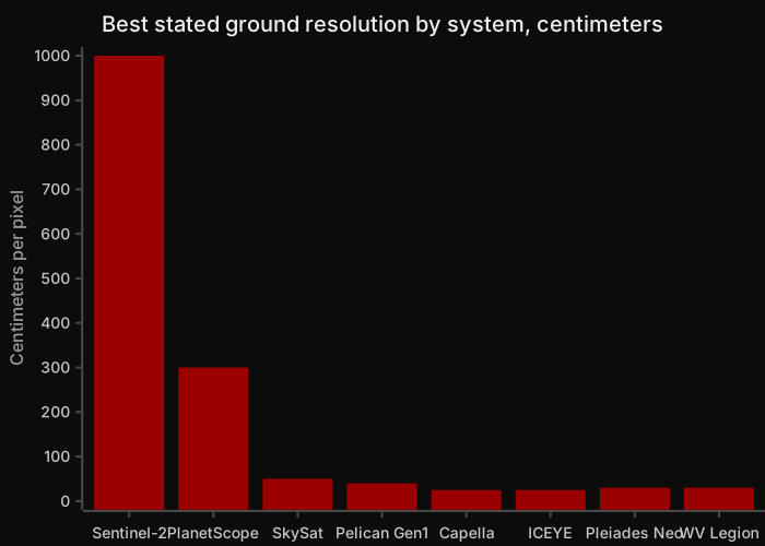 Source: ESA Sentinel-2 facts and figures; Planet (2025); ICEYE (2026); Capella Space; Airbus; Vantor/Maxar distributor material, 2024–2026. Lower bars mean finer detail.
Spectral and radar information#
Resolution is not the only variable. Multispectral sensors capture bands beyond visible light, such as near-infrared, which reveals vegetation health, or short-wave infrared, which can show heat and burn scars. SAR imagery adds a different kind of information: surface roughness, metal reflectivity and, through a technique called coherence change detection, very subtle ground disturbance between two passes. An experienced analyst often combines a low-resolution daily image to spot that something has changed with a high-resolution tasked image to determine what it is.
Revisit rates and the crowded orbit#
Why revisit matters as much as resolution#
Revisit rate describes how often a satellite or constellation can image the same point. A single high-resolution satellite in sun-synchronous orbit may pass over a location only every few days, and only at a similar local time. Constellations change that equation: Vantor's mixture of sun-synchronous and mid-inclination Legion satellites allows imaging at different times of day, and Planet's fleet of small satellites was designed specifically for near-daily global coverage. For conflict monitoring, frequent revisit turns isolated snapshots into time series, which is what allows analysts to see a buildup develop, a convoy depart or a bridge collapse.
How many satellites are watching#
The number of satellites in orbit has grown at an unprecedented pace, though most of the growth is in communications rather than Earth observation. According to the Look Up Space orbital barometer produced with Le Point, there were 13,026 active satellites on 1 October 2025, up 23 percent year on year, and 15,711 at the start of June 2026, of which 10,365 were SpaceX Starlink satellites. ESA's Space Environment Report 2026 noted that more than 4,000 new payloads were launched in 2025 alone. Earth observation is a smaller slice: the Union of Concerned Scientists database counted 1,192 operational Earth observation or Earth science satellites at the end of 2022, its last comprehensive public update.
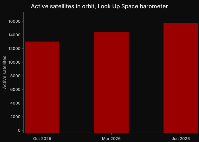 Source: Look Up Space and Le Point orbital barometer, October 2025 to June 2026 editions.
Who operates the Earth observation fleet#
Within that Earth observation population, a small number of operators dominate. The Union of Concerned Scientists data, as summarized by Pixalytics, shows Planet as the largest single operator with 195 satellites at the end of 2022, followed by Spire Global with 126 (mostly radio-occultation and maritime-tracking satellites) and China's Ministry of National Defense with 98. The US National Reconnaissance Office was listed with 31 satellites, a number that only reflects publicly catalogued systems. These figures predate the rapid growth of SAR constellations such as ICEYE's, which has more than tripled since.
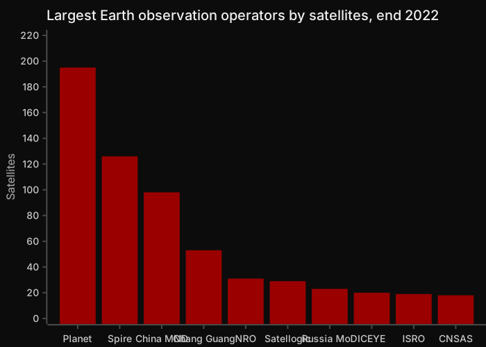 Source: Union of Concerned Scientists Satellite Database as of 31 December 2022, compiled by Pixalytics, 2023.
Notable uses in recent conflicts and crises#
Russia's buildup near Ukraine, 2021–22#
The months before Russia's full-scale invasion of Ukraine in February 2022 were the first major crisis in which commercial satellite imagery intelligence shaped public debate in near real time. Maxar images published in November 2021 showed elements of Russia's 41st Combined Arms Army deployed at a training area near Yelnya, roughly 160 miles from the Ukrainian border, with hundreds of tanks and self-propelled artillery. Through December and January, further imagery showed battle groups at Pogonovo near Voronezh and equipment at Klimovo and Klintsy in Bryansk Oblast. Moscow consistently described these as exercises and denied planning an invasion. The imagery did not prove intent, but it gave journalists, analysts and governments a shared, verifiable picture of force posture, and it complemented the unusual public disclosures of US and UK intelligence.
North Korea's nuclear and missile programs#
North Korea is one of the most closed states on Earth, and satellite imagery intelligence is one of the few windows into its weapons programs. Research outlets such as 38 North and CSIS's Beyond Parallel publish regular imagery analysis of sites including the Yongbyon Nuclear Scientific Research Center. In June 2025, 38 North reported a suspected new uranium enrichment building at Yongbyon, about 120 m by 47 m, whose footprint and security features resembled the suspected Kangson enrichment facility; the analysis used Airbus Pléiades Neo, Maxar and Planet imagery to date construction from December 2024 to mid-2025. The report noted that International Atomic Energy Agency Director General Rafael Grossi had also said the facility was likely for enrichment.
Detention facilities in Xinjiang#
In September 2020, the Australian Strategic Policy Institute's Xinjiang Data Project identified more than 380 suspected detention facilities in Xinjiang using satellite imagery combined with witness accounts, media reports and official construction tender documents. Researchers classified sites by features such as high walls, watchtowers and internal fencing, and reported that at least 61 sites had seen new construction or expansion in the year to July 2020. China's government describes the facilities as vocational skills education and training centers intended to counter extremism and has rejected the findings. The case illustrates both the power of imagery to document change in inaccessible regions and the need to fuse it with other evidence to interpret function.
Damage assessments in Gaza#
The UN Satellite Centre (UNOSAT) has produced a series of comprehensive damage assessments of the Gaza Strip since the war began in October 2023. Its assessment based on imagery collected on 11 October 2025 identified 198,273 affected structures, approximately 81 percent of all structures in the Gaza Strip, including 123,464 destroyed. UNOSAT stated that the analysis was preliminary and had not yet been validated in the field. Israel's government has said its operations target Hamas military infrastructure, including tunnels and positions in civilian buildings, while Palestinian authorities and UN agencies have emphasized the humanitarian consequences of the destruction. The damage data itself is used by aid agencies for planning shelter, debris removal and reconstruction.
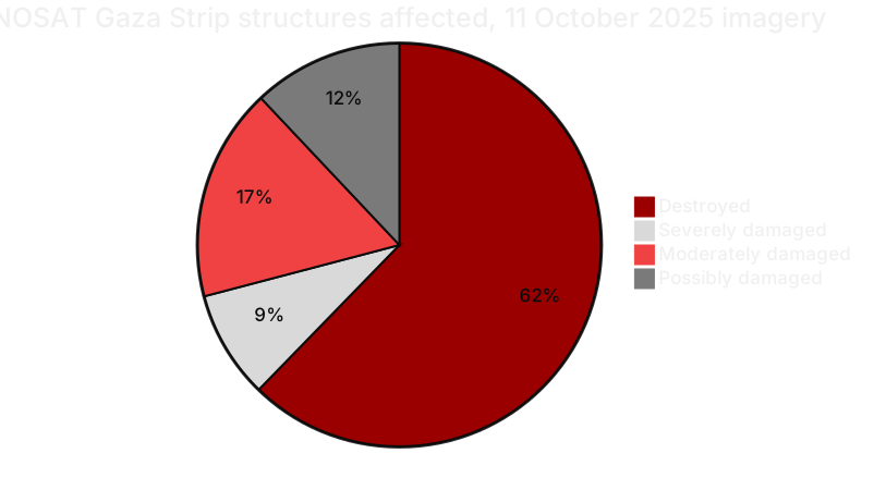 Source: UNOSAT Gaza Strip Comprehensive Damage Assessment, imagery of 11 October 2025, published 31 October 2025.
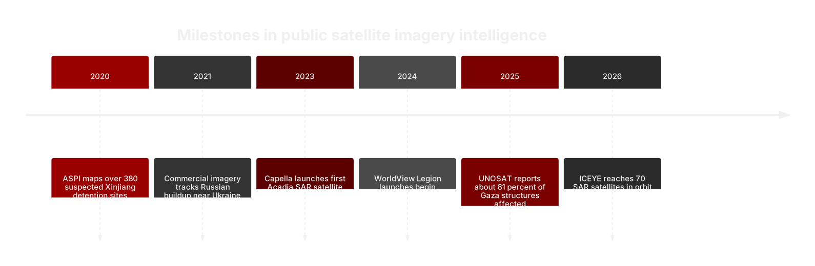 Source: ASPI (2020); Maxar via Military Times (2022); Capella Space (2023); European Space Imaging (2024); UNOSAT (2025); ICEYE via Calibre Defence (2026).
AI and the automation of imagery analysis#
The volume problem#
The growth of constellations has created a data problem that human analysts cannot solve alone. A daily global image set at 3 m resolution, combined with tasked high-resolution collection and SAR, produces far more pixels than any team can inspect. Machine learning has therefore become central to modern GEOINT: computer vision models detect aircraft, ships, vehicles and buildings, flag change between collections and prioritize which images an analyst should examine first. Commercial firms increasingly sell analytics, such as object counts or change alerts, rather than raw images.
Maven and government adoption#
The most prominent government example is Project Maven, the Pentagon's computer vision effort launched in 2017. NGA took over much of Maven in 2022–23, and it became a program of record in November 2023. Public reporting indicates that Maven had more than 20,000 active users by May 2025 and that the Pentagon raised the ceiling on the Maven Smart System contract to $1.3 billion through 2029. In September 2025, NGA's director said Maven would begin transmitting "100 percent machine-generated" intelligence by June 2026, and in March 2026 reporting indicated the program would move from NGA to the Pentagon's Chief Digital and AI Office.
Where human judgment remains essential#
Automation accelerates detection but does not remove the need for analytical judgment. Models trained on one region or season can fail in another; decoys, camouflage and unusual equipment can confuse classifiers; and a correct detection says nothing on its own about intent. Responsible practice keeps a human analyst accountable for conclusions, documents model confidence and validates findings against other sources. In conflict settings, where imagery may inform targeting or legal accountability, those safeguards are an ethical requirement as well as a quality control.
Limits, restrictions and ethics#
Physical and analytical limits#
Optical satellites are blocked by cloud, smoke and darkness, and even SAR has trade-offs in interpretability. Imagery captures surfaces, not interiors: it cannot see inside a hardened shelter or underground facility, and it can be deceived by decoys, a long-standing military practice. Time of day, sun angle and off-nadir viewing can distort what an image appears to show. Above all, a satellite image is evidence of physical conditions at one moment; claims about who caused damage, or why a force has moved, require corroborating intelligence.
Access can be restricted#
Commercial imagery is subject to government licensing and corporate policy. For more than two decades, the US Kyl-Bingaman Amendment limited US-licensed imagery of Israel to 2 m resolution; in July 2020, the Commerce Department relaxed the limit to 0.4 m after finding that such imagery was available from non-US sources. In March 2025, NGA suspended Ukraine's access to commercial imagery through the GEGD portal following the US pause in intelligence support to Kyiv. In March 2026, after the US-Israeli strikes on Iran began, Planet imposed a 14-day delay on imagery of Iran, the Gulf states and nearby areas, stating that it wanted to prevent adversaries from using its images to target allied personnel and civilians. Such decisions show that the open availability of imagery depends on policy choices that can change quickly.
Privacy, safety and responsible publication#
Higher resolution and more frequent revisit raise legitimate concerns. Imagery can expose the positions of civilians, aid convoys or military personnel, and publication during active hostilities may aid targeting. Researchers and media organizations increasingly apply publication delays, blur sensitive details and weigh the public-interest value of an image against potential harm. The best open-source GEOINT practitioners publish their methods and uncertainties so that others can test their conclusions, an approach that strengthens credibility and reduces the risk of error amplifying through social media.
Frequently asked questions#
What is the difference between GEOINT and IMINT?#
Imagery intelligence (IMINT) refers to intelligence derived from interpreting images, whether from aircraft, drones or satellites. Geospatial intelligence (GEOINT) is broader. Under US law it includes imagery, imagery intelligence and geospatial information, such as maps, elevation data and navigation information, and the analysis that places all of these on a common geographic frame. In practice, IMINT is now treated as a component of GEOINT. A GEOINT product might combine a satellite image with terrain data, road networks, historical imagery and location-tagged open-source reporting to answer a question about activity at a specific place and time.
How detailed is commercial satellite imagery today?#
The finest commercial optical imagery is in the 30 cm class, offered by Vantor's WorldView Legion and Airbus's Pléiades Neo, with Airbus planning Pléiades Neo Next at below 30 cm native resolution. Commercial SAR providers ICEYE and Capella advertise products around 25 cm. At 30 cm, analysts can generally recognize vehicle types, count aircraft and assess roof-level building damage, but cannot read license plates or identify people's faces. Free government sources such as Sentinel-2, at 10 m, are much coarser but useful for large-scale change.
Can satellites see through clouds or at night?#
Optical satellites, which work like cameras, cannot see through cloud and need daylight for standard imagery, although some carry thermal or low-light sensors. Synthetic aperture radar satellites can image through cloud, smoke and darkness because they emit their own microwave signal and record its reflection. This makes SAR particularly valuable in regions with persistent cloud cover and during night-time military activity. SAR images require specialist interpretation, since they record surface roughness and reflectivity rather than color, and metal objects such as vehicles or ships often appear as bright points.
How often can a satellite image the same place?#
It depends on the satellite and the constellation. A single high-resolution satellite in a sun-synchronous orbit may revisit a given location only every few days. Constellations shorten that interval: Planet's small-satellite fleet was built to image the Earth's landmass nearly every day at roughly 3 m resolution, and Vantor's distributor states WorldView Legion can revisit some locations up to 15 times a day. Sentinel-2 achieves a five-day revisit at the equator with two satellites. Cloud cover and tasking priorities determine how many usable images actually result.
Who uses satellite imagery intelligence outside government?#
Users include journalists verifying claims about conflict, humanitarian agencies such as UNOSAT assessing damage, human rights researchers documenting abuses, think tanks tracking weapons programs and companies monitoring supply chains, commodities, shipping and infrastructure. Insurers use imagery for catastrophe claims, and agricultural firms use it to estimate yields. Because imagery can be dated and shared, it has become a common evidential standard in open-source investigations, often combined with social media footage, shipping data and other public records to build a verifiable picture.
Is satellite imagery always reliable evidence?#
Imagery is strong evidence of physical conditions at a specific time, but it has limits. It can be affected by cloud, sun angle and viewing geometry, and it cannot show what happens inside buildings or underground. Decoys and camouflage can mislead, and machine-learning detections can produce false positives. Most importantly, imagery rarely establishes intent or responsibility by itself. Reliable analysis states its method, dates every image, notes uncertainty and corroborates findings with other sources before drawing conclusions about who did what and why.
The RAGE X view#
Satellite imagery intelligence has democratized a capability once reserved for superpowers, and the result has been a more transparent information environment around conflict. The public record of Russia's 2021–22 buildup, North Korea's enrichment construction and the scale of destruction in Gaza rests to a significant extent on imagery that anyone with the right access can check. That transparency is valuable, but it is conditional. Licensing rules, corporate delays and government access decisions in 2025 and 2026 showed that the window can narrow when it matters most, and the analytic burden of separating what an image shows from what it implies remains with the analyst.
At RAGE X, we treat imagery as one strand of evidence rather than the final word, fusing it with open-source reporting, official statements and historical baselines. That approach underpins RAGE INDEX, our live global conflict intelligence product, and the reporting on RAGE Intel. As constellations grow and AI takes over more first-pass detection, the decisive advantage will belong to those who combine machine speed with disciplined, transparent human judgment.
Sources#
- US Code, 10 U.S.C. § 467, Definitions (geospatial intelligence) — Cornell Legal Information Institute: https://www.law.cornell.edu/uscode/text/10/467
- Breaking Defense, "NGA suspends Ukraine's access to commercial satellite imagery," March 2025: https://breakingdefense.com/2025/03/nga-suspends-ukraines-access-to-commercial-satellite-imagery
- European Space Imaging, "Maxar WorldView Legion Satellites: The Successful Launch and Its Impact," November 2024: https://www.euspaceimaging.com/blog/2024/11/29/worldview-legion-launch-and-applications
- Forecast International, "Maxar retires its name as Vantor and Lanteris emerge from corporate split," October 2025: https://flightplan.forecastinternational.com/2025/10/01/maxar-retires-its-name-as-vantor-and-lanteris-emerge-from-corporate-split/
- Planet, "Planet Launches High-Resolution Pelican-5, Pelican-6 Satellites and 36 SuperDoves," November 2025: https://investors.planet.com/news/news-details/2025/Planet-Launches-High-Resolution-Pelican-5-Pelican-6-Satellites-and-36-SuperDoves/default.aspx
- Airbus, "Pléiades Neo Next": https://space-solutions.airbus.com/resources/news/events/pleiades-neo-next/
- ESA, "Pléiades celebrates 10 years and extends satellite fleet with Pléiades Neo," December 2021: https://earth.esa.int/eogateway/news/pleiades-celebrates-10-years-and-extends-satellite-fleet-with-pleiades-neo
- Calibre Defence, "ICEYE deploys 70th satellite in recent launch," March 2026: https://www.calibredefence.co.uk/?p=6321
- BusinessWire, "IonQ Completes Acquisition of Capella Space," July 2025: https://www.businesswire.com/news/home/20250715219783/en/ionq-completes-acquisition-of-capella-space-advancing-vision-for-space-based-quantum-communications
- Capella Space overview and launch history (Wikipedia, with primary citations): https://en.wikipedia.org/wiki/Capella_Space
- ESA, Sentinel-2 facts and figures: https://www.esa.int/Applications/Observing_the_Earth/Copernicus/Sentinel-2/Facts_and_figures
- ATC Network, "Look Up and Le Point unveil their first space barometer: 13,026 active satellites as of October 1, 2025": https://www.atc-network.com/atc-news/look-up-and-le-point-unveil-their-first-exclusive-space-barometer-orbital-traffic-surges-13026-active-satellites-as-of-october-1-2025
- Space Daily, "Active satellites 2019–2026: Starlink two-thirds," 2026: https://spacedaily.com/t-active-satellites-2019-2026-starlink-two-thirds/
- ESA Space Environment Report 2026: https://www.esa.int/Space_Safety/Space_Debris/ESA_Space_Environment_Report_2026
- Union of Concerned Scientists, Satellite Database: https://www.ucs.org/resources/satellite-database
- Pixalytics, "How many Earth observation satellites orbiting in 2023?": https://www.pixalytics.com/earth-observation-satellites-2023/
- Military Times, "Satellite images track Russian troops near Ukraine," January 2022: https://www.militarytimes.com/gallery/2022/01/20/satellite-images-track-russian-troops-near-ukraine/
- 38 North, "Yongbyon Nuclear Scientific Research Center: A Suspected New Enrichment Facility and Dismantlement of 50 MWe Reactor," June 2025: https://www.38north.org/2025/06/yongbyon-nuclear-research-center-a-suspected-new-enrichment-facility-dismantlement-50mwe-reactor/
- Al Jazeera, "China running 380 detention centres in Xinjiang: Researchers," September 2020: https://www.aljazeera.com/news/2020/9/24/china-running-380-detention-centres-in-xinjiang-researchers
- UN (UNISPAL), "UNOSAT Gaza Strip Damage Assessment," 31 October 2025: https://www.un.org/unispal/document/unosat-gaza-strip-damage-assessment-31oct25/
- Wikipedia summary of public reporting on Project Maven (with primary citations): https://en.wikipedia.org/wiki/Project_Maven
- Breaking Defense, "Now that Maven is a program of record, NGA looks at LLMs, data labeling," November 2023: https://breakingdefense.com/2023/11/now-that-maven-is-a-program-of-record-nga-looks-at-llms-data-labeling/
- US Department of Commerce, Office of Space Commerce, "New Limits on Satellite Imaging of Israel," 2020: https://space.commerce.gov/?p=3951
- Al-Monitor, "US satellite firm extends Middle East image delay," March 2026: https://www.al-monitor.com/originals/2026/03/us-satellite-firm-extends-middle-east-image-delay
About RAGE X: RAGE X is a global media, intelligence and technology organization delivering geopolitical intelligence, military and conflict analysis, OSINT and security insight through RAGE Intel, RAGE INDEX and its wider ecosystem at theragex.com.
Continue the assessment
Related Intelligence
What Is OSINT? The Complete Guide to Open-Source Intelligence
What is OSINT? A complete guide to open-source intelligence: definition, history, intelligence cycle, core techniques, ethics, case studies and careers.
2026-10-21 · 17 min read
How Geopolitical Risk Is Measured: Indices, Methods and Early-Warning Signals
How is geopolitical risk measured? A guide to the GPR index, ACLED, UCDP, the Global Peace Index, the Fragile States Index and early-warning signals.
2026-10-21 · 16 min read
Intelligence Analysis 101: How Analysts Turn Raw Information into Insight
Intelligence analysis explained: the intelligence cycle, collection disciplines, structured analytic techniques, ICD 203 and PHIA probability yardsticks.
2026-10-21 · 15 min read
Today's conflict risk
The daily RAGE INDEX scores global conflict risk across six theaters, with sources and forecasts.
Read the RAGE INDEXReach readers like these
RAGE X sells sponsored content across RAGE Intel, RAGE War and RAGE Global by proposal, always labelled as sponsored.
Request a campaign proposal